- Home ›
- NZ Cities ›
- Christchurch ›
- Lyttelton
Lyttelton New Zealand Harbour / Whakaraupō, Christchurch
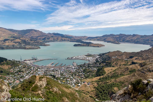
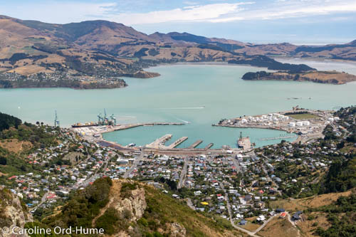
The creation of Lyttelton Harbour docks and port was taking advantage of a steep sided extinct volcanic crater full of deep water providing excellent anchorage for ships.
View of Lyttelton Harbour from Mount Pleasant

The small port town of Lyttelton, built in its picturesque setting on the side of the Port Hills, is merely 12km southeast from the middle of Christchurch.
Lyttelton Harbour has plenty to offer for those who enjoy being on or around the water, such as yachting and water skiing, fishing, bays and beaches for swimming.
At Lyttelton Port and on the wharf you can find places to eat and drink, and a local farmers market to get some provisions.
Tunnel to Lyttelton
It only takes minutes to get to Lyttelton through the longest road tunnel in New Zealand, see below for directions.
The Port of Lyttelton greets you as you come out of the tunnel, a busy port with extensive shipping services bringing in trade to Canterbury and Christchurch every day of the year.
Lyttelton Tours and Activities
- Christchurch Gondola
- Diamond Harbour
- Jack Tar Sailing
- Lyttelton Torpedo Boat Museum
- Norman Kirk Memorial Summer Pool
- Orton Bradley Park
- Poetry Tour - Walking
- Preserved Cook School and Shop
- Quail Island
- She Universe Café and Chocolatier School
- Steam Tug Lyttelton
Lyttelton Walking and Hiking
- Hays Bay to Church Bay
- Orton Bradley Park
- Packhorse Hut
- Quail Island
- Rod Donald Hut
- Stoddart Point Reserve Upoko o Kuri
Trails and Hill Walking
Pick up a map leaflet of Lyttelton Town and Hill Walks to find out where there are trails and tracks to take you… into the surrounding hills and/or along the coastline from Lyttelton town and port. Get the brochure from the Lyttelton Information Centre, 20 Oxford Street, Lyttelton, or the Department of Conservation (DOC) Visitor Centre, 28 Worcester Boulevard, Christchurch.
- Coastal Walk to Pony Point Reserve
- Nooks and Crannies Walk
- Bridle Path and Stan Helms - Pioneer Women's Memorial
- Foreshore Walkway Naval Point
- Major Hornbrook Reserve - Gondola
- Ōhinehou Skyline Circuit
- Urumau Reserve Loop - Gun Emplacements
- Whakaraupo Loop
Or join in with the Banks Peninsula Walking Festival in November of every year.
Also see Banks Peninsula Walks for more hiking and tramping on the peninsula.
Lyttelton Historical Sites
- Allandale District Lockup
- Antarctic Port Sled Dog Statue
- Grubb Cottage
- Lyttelton Railway Station Signal Box
- Lyttelton Torpedo Boat Museum
- Mill House & Stone Cottage
- Packhorse Hut
- Pilgrims Rock
- Quail Island
- St Saviour’s Chapel
- Steam Tug Lyttelton
- Stoddart Cottage
Scenic Places and Beaches
- Albion Square
- Allandale Reserve
- Cass Bay - Motu Kauati-rahi
- Corsair Bay - Motu Kauati-iti
- Hays bay to Church bay
- Orton Bradley Park
- Pony Point
- Purau Bay
- Stoddart Point Reserve Upoko o Kuri
Getting to Lyttelton
To drive to Lyttelton from Christchurch you need to take SH74. Alternatively take SH76 which then joins onto SH74.
SH74 is otherwise named Tunnel Road and will take you past Christchurch Gondola to drive through the longest tunnel through hills in New Zealand that goes to Lyttelton Port and Lyttelton Harbour.
Christchurch City Roads and Routes
Lyttelton Port, Docks, Town, and Lyttelton Harbour, New Zealand

Events
Check out Project Lyttelton to find out what events are on at different times of the year.