- Home ›
- NZ Regions ›
- Southland ›
- Te Anau ›
- The Milford Road
Milford Road from Te Anau to Milford Sound: Route and Attractions, Fiordland
Te Anau to Milford Sound / Piopiotahi route along The Milford Road is 74 miles (119km).
State Highway 94 (SH94) / Te Anau Milford Highway.
There is a map of the entire route below.
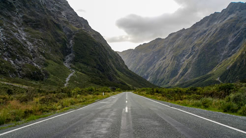
Photo by Geoff Byron
Things to do on The Milford Road Route from Te Anau to Milford Sound
Along Milford Road, from Te Anau to Milford Sound / Piopiotahi, the following is a list of the main attractions where you can stop along the route and either soak up the amazing Fiordland National Park views, or go for walks to see specific attractions and sites of interest.
Five Mile Lookout
Location: On the Milford Road, Five Mile Lookout offers views of Lake Te Anau and South Fiord.
Five Mile Lookout is an ideal starting point for your journey along the Milford Road. From this vantage point, you can marvel at the breathtaking views of Lake Te Anau and the expansive South Fiord of Lake Te Anau. It's the perfect introduction to the natural beauty that you will experience while driving the Te Anau Milford Highway to Milford Sound.
Lake Mistletoe
Location: Along the Milford Road, Lake Mistletoe is accessible via a 45-minute return forest walk.
Lake Mistletoe is a serene spot along the route, inviting you to take a leisurely 45-minute walk through the lush native forest surrounding the lake. It's a peaceful place where you can connect with nature and, if you are quiet, spot some Fiordland National Park wildlife.
Te Anau Downs
Location: Departure wharf for the famous Milford Track, Te Anau Downs Boat Launch, Milford Road.
Te Anau Downs serves as the starting point for those embarking on the renowned Milford Track, one of New Zealand's Great Walks. As you pass through, depending on the season, you may see the preparations and excitement of hikers beginning their journey into the pristine wilderness of Fiordland National Park.
Fiordland National Park Tracks
- Kepler Track
- Milford Track
- Routeburn Track
- Hollyford Track
- Dusky Track
- Great Walks List
Eglinton Valley Viewpoint Riverside
Location: Overlooking the scenic Eglinton Valley.
The Eglinton Valley Viewpoint offers sweeping vistas of the Eglinton Valley, a picturesque landscape framed by towering mountains. This viewpoint is next to the Eglinton River and an excellent place to stop and take in the grandeur of the surrounding Fiordland wilderness.
Mirror Lakes Viewpoint
Location: A short 5-minute walk to a serene location with reflections and a habitat for forest and wetland birds.
Mirror Lakes lives up to its name, offering awesome reflections of the surrounding landscape in the lakes on calm days. Take a brief stroll to this tranquil spot to enjoy the mirrored beauty of the mountains and perhaps see some of New Zealand's unique native birdlife.
Knobs Flat
Knobs Flat is an informative stop where you can see conservation displays. This is where you can learn more about the efforts to protect and preserve the natural treasures of Fiordland National Park.
Lake Gunn Nature Walk
Location: A 45-minute loop walk through beautiful Fiordland beech forest.
The Lake Gunn Nature Walk is a delightful 45-minute loop that takes you through enchanting native beech forest. Immerse yourself in the sounds of New Zealand bush as you meander along this well-maintained walking trail.
The Divide
Location: The starting point for the Routeburn Track and Greenstone Tracks.
The Divide marks the beginning of two of the most iconic New Zealand hiking trails: the Routeburn Track and the Greenstone Track. Hikers and nature enthusiasts converge here to embark on these renowned journeys into the heart of Fiordland's wilderness.
Key Summit
Location: A 3-hour return track starting from the Divide car park.
For those seeking a more challenging hike, the Key Summit track offers a rewarding 3-hour return journey. The track leads you to Key Summit, where you can enjoy panoramic views of the surrounding mountains of Southland and pristine alpine landscapes.
Pop’s View
Location: Milford Road
Pop’s View Lookout is a roadside viewpoint offering a stunning perspective of the Hollyford Valley. Definitely take a stop here to capture the picturesque scenery and take in the vastness of the valley.
Detour: Turn right onto Lower Hollyford Road to get to:
Lake Marian Tracks
Location: Lower Hollyford Road
Lake Marian Tracks offer two distinct experiences. A 20-minute return walk takes you to picturesque Marian Falls waterfalls, while a 3-hour return hike leads you to the pristine Lake Marian. Both options offer a chance to immerse yourself in the natural beauty of the area.
Gunn’s Camp and Museum
Location: Lower Hollyford Road
Gunn’s Camp and Museum provides insight into the European history of the Hollyford Valley. Explore the exhibits and learn about the early settlers who called this remote valley home.
Humboldt Falls
Location: Lower Hollyford Road. A 30-minute return walk to the waterfalls.
Humboldt Falls is a hidden gem along the Milford Road. A 30-minute walk takes you through lush rainforest to a beautiful waterfall, making it a worthwhile stop for nature lovers.
Start of the Hollyford Track
The end of Hollyford Road is the start of the Hollyford Track
Return to Milford Road to Continue to Milford Sound:
Falls Creek Route Trail
Location: Milford Road
Falls Creek Route Trailhead takes you to the stunning Christie Falls.
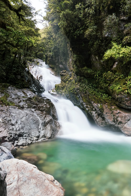
Photo by Eyrie Photography
Monkey Creek Viewpoint
Location: Milford Road
Monkey Creek Viewpoint offers a picturesque stop along the route. Take in the surrounding scenery and, if you're lucky, you might spot some of the local native New Zealand wildlife that frequent the area.
Gertrude Saddle Track and Gertrude Valley Lookout
Location: Milford Road
The Gertrude Saddle Track is a challenging 4-hour return hike tailored for experienced walkers. It rewards hikers with stunning alpine vistas and the opportunity to immerse themselves in Fiordland National Park's rugged beauty.
Homer Tunnel Viewpoint and Nature Walk
Location: Milford Road
This is a 20-minute alpine walk that provides an opportunity for you to stretch your legs and admire the Southland alpine scenery near the iconic Homer Tunnel.
The Chasm
Location: Milford Road
The Chasm is a captivating natural wonder. A 20-minute return walk takes you to a water-sculpted chasm, where you can witness the power of nature as rushing water has shaped the rock formations over time.
Tutoko Historic 1936 Suspension Bridge
Location: Milford Road
Stop here to enjoy captivating views of the mountain, river, and native forest landscapes while standing on the Tutoko suspension bridge. It's a scenic spot along the Te Anau to Milford Sound route.
Milford / Piopiotahi Walks
Location: Milford / Piopiotahi
Milford Sound, also known as Piopiotahi, offers various short walks to explore the beauty of this world-renowned fiord. These walks provide a chance to appreciate the stunning natural surroundings of Fiordland National Park and perhaps spot some local wildlife… if you are not too noisy.

Photo by Timothy Chan
Wildlife
There are plenty of opportunities to see wildlife along the route from Te Anau to Milford Sound. When you get to Milford Sound, look out for seals, dolphins, and native birds that live in the Fiordland National Park if you take a cruise.
Camping and Campsites Along Milford Road
Along the route of Milford Road, you are only permitted to camp at designated Department of Conservation campsites or at commercial accommodation. To preserve the unique environment of Fiordland National Park it is really important to stick to the camping rules.
Camping is available in these locations betweet Te Anau and Milford Sound. I believe booking is advised.
- Henry Creek
- Walker Creek
- Totara
- Mackay
- Deer Flat
- Kiosk Creek
- Smithy Creek
- Upper Eglinton
- Cascade Creek
- Lake Gunn
Campervan Toilet Waste Disposal
Campervan and motorhome toilet waste should only be disposed of at waste stations. These can be found at the following locations.
- Te Anau
- Knobs Flat
- Milford Sound / Piopiotahi
Milford Road Conditions and Adverse Weather Impacts
The winter months, between May and November, sometimes mean Milford Road can be subject to adverse weather conditions such as snow. Any road closures and/or restrictions will be notified by roadside signs.
During avalanche season, there will be restrictions in place such as ‘No Stopping’ when driving, and no walking or cycling. These restrictions are due to risk of avalanche along a specific stretch of Milford Road (Falls Creek to the Chasm) and should be adhered to. It prevents the avalanche risk to visitors and to rescue services personnel.
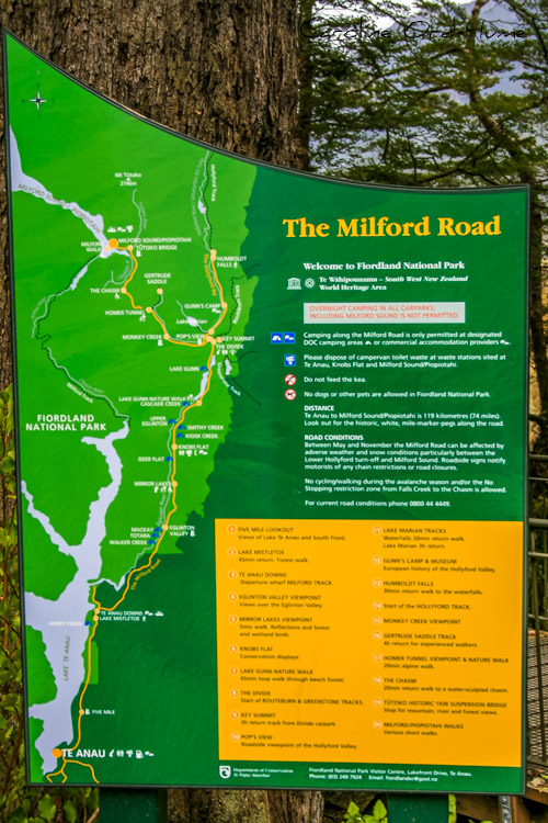
See Map of Milford Road from Te Anau to Milford Sound Below
Fiordland National Park Tracks
- Kepler Track
- Milford Track
- Routeburn Track
- Hollyford Track
- Dusky Track
- Great Walks List
Map of Te Anau Milford Highway - State Highway 94 (SH94)
Te Anau to Milford Sound / Piopiotahi route along The Milford Road is 74 miles (119km).
State Highway 94 (SH94) / Te Anau Milford Highway.